What Is a Site Plan? 11 Things Good Site Plans Must Include
Jun 30, 2020

If you’re building a simple project like a shed, simply sketching the details on a piece of paper will give you most of the information you need. But when you’re building a house or commercial project, you need a far more detailed plan.
What is a site plan?
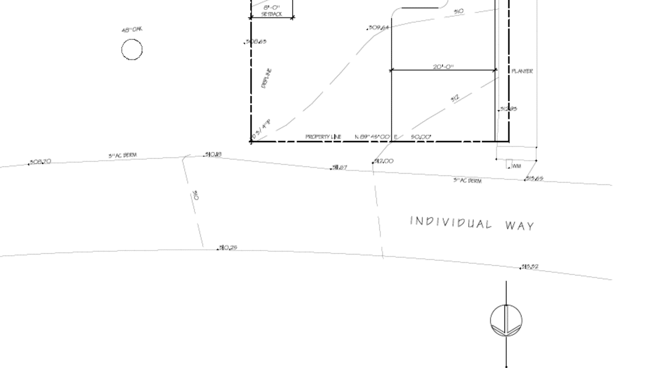
A site plan—sometimes called a plot plan—is an architectural document that functions as a readable map of a building site, giving you all the details you need to know about how the structure will be oriented on the lot. A builder or contractor will create a diagram that shows the plot of land and its property lines, along with its landscape features, structural elements, setbacks, driveways, utility poles and power lines, fencing, and on-site structures.
Even landscape elements that don’t sit right on your property might be recorded on a site plan, says Jordan Smith, because the site notes can contain valuable information that impact your property. For instance, a tree on a neighbor’s property might impact the way you protect the land in your lot.
The site plan often appears on the title page of your property’s collection of documents (known collectively as blueprints) and functions as the overview of the property. It includes the sheet index of all the different prints.
Most site plans are 2D aerial maps that give you a clear overview of your property’s features. A 3D rendering is a three-dimensional, full-color plan that’s particularly useful for understanding the landscape, including plantings, the building’s parking, and outdoor structures.
Site plans are only one component of a property’s blueprints. Learn everything you need to know about reading blueprints in MT Copeland’s online class, taught by professional builder and craftsman Jordan Smith.
What are the uses of a site plan?
In addition to use by architects and contractors, site plans have several other important functions. County governments require that you file site plans so they can make sure that the state and local building codes are followed. They are also a historical record of the structure, and any alterations a property owner has made over time.
Real estate agents use site plans to show all the home’s key features, including the size, scale, and orientation, and key outdoor features.
For those working on home improvement projects like a new pool, home addition or a deck, you’ll use the site plan to plot out those revisions. “Instead of just drawing up a patio and sending it out, we’ll put it on the original prints and we’ll make a revision,” builder and craftsman Jordan Smith explains. You might even see possibilities in a site plan that you hadn’t originally considered, such as space for an additional landscape feature or outdoor room.
What’s the difference between a site plan and a floor plan?
A site plan is different from a floor plan, in that a site plan is a comprehensive view from above of the entire property, while a floor plan shows a building footprint: the interior walls and features. Floor plans aren’t generally included with the site plan, unless the property is altered in a way that affects the footprint of the house.
When reading a site plan, it’s important to understand the difference between the “Project North” designation and the cardinal north, south, east, and west on a compass.
“We try to orient our houses in a square way to the sheet,” Smith explains. “It’s a way to navigate through a house simply using north, east, south, and west without having to actually know where due north is.”
11 Elements of a good site plan
Here are the 11 things a good site plan must include:
- Directions, notes, and abbreviations, as well as project data and a vicinity map.
- Property lines: Property lines are called out around the exterior of the lot.
- Setbacks: These are the spaces between a building and its property line.
- Existing and proposed conditions: Fence lines, utility and power lines need to be shown on your site map. These will also illustrate whether inspectors need to be called in during the construction process.
- Construction limits: This will show the parts of the property where the construction is happening and show the areas near the site where you’ll be taking up space for equipment parking and storage.
- Parking: A site plan will always show parking dimensions, including parking spaces, areas for turning around, and especially in urban and high-traffic areas, the flow of traffic.
- Surrounding streets and street signs: Along with the flow of traffic, a site plan will show you how your property functions within the streets and avenues that surround it, or if it is at the end of a quiet cul-de-sac. You’ll also be able to see these features in a separate “vicinity map.”
- Driveways: A good site plan usually shows the exact dimensions of driveways and curbs.
- Fire Hydrants: City codes govern the distance your property must be from fire hydrants, and a new construction site plan will also include these when they are submitted for approval to the city.
- Easements: Site plans will always include easements, which is a feature of your property that is shared by someone else for a specific purpose. Examples include a pathway through your property to a neighborhood park, utility lines, or parts of the property that are maintained by a homeowners association.
- Landscaped areas: A good site plan will include not only the measurement, but also the type of landscape feature (such as a deciduous tree, or a desert landscape) and retaining walls.
MT Copeland offers video-based online classes that give you a foundation in construction fundamentals with real-world applications. Classes include professionally produced videos taught by practicing craftspeople, and supplementary downloads like quizzes, blueprints, and other materials to help you master the skills.


